Udemy – Photogrammetry With Drones: In Mapping Technology
 2018-09-8

 2 031
2 031
 0
0

Photogrammetry With Drones: In Mapping Technology – download video сourse by Udemy
What Will I Learn?
Elaborate the concepts on Photogrammetry
Explain general applications and uses of Photogrammetry
Formulate steps to execute a photogrammetry project
Explain types and properties of Aerial Photographs in Photogrammetry
Interpret aerial photographs for feature identification
Apply DSM, DTM,TIN and Contours in Photogrammetry
Explain Engineering drawing for 3D perspective
Apply the features of Microstation tools in compilation
Build planimetric features in 3D environment using PRO600, Viewplex, PROCart
Build DTM features in Photogrammetry using PROCart
Develop expertise to handle TerraModel to generate Contours, TIN and Shaded Surface using DTM features in Photogrammetry
Requirements
The course is for beginners, Freshers or for those transitioning from another industry or discipline.
Must be capable of using Computer Systems.
Must have Basic knowledge of the AEC Industry, its tools & technology.
Zest to learn new technology.
Description
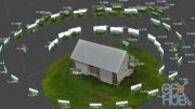
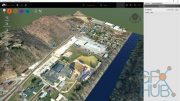
Photogrammetry uses measurements from photographs by analyzing points on an object and creates a 3D model using this information. As an integrated package, this online course provides valuable learning material on software like MicroStation, LPS (Leica Photogrammetry Suit) and PRO600, TerraModel.
Users can leverage very high detail of output through precise input information from aerial photographs. Course Participants will also identify concepts on Stereo Compilation (3D), which serves as a core process for photogrammetry.
After successful completion of this course, students will be able to-
I. Use their skills for MicroStation as Mapping software for Photogrammetry
II. Use their skills for PRO600-PROCart as a Photogrammetry software.
III. Compile planimetric features & DTM using 3D environment in LPS
IV. Construct Contours, Shaded Surfaces & TIN using TerraModel in Photogrammetry
V. Demonstrate work flow followed in Photogrammetry projects
Who is the target audience?
Geography Graduate students
Diploma /Graduate Engineering students
Diploma / Graduate in any discipline
This program is designed for students and professionals to perceive better careers and upgrade their skill sets.
MP4 1280x720 | 1h 57m | ENG | 894 MB
Download links:

Udemy_-_Photogrammetry_With_Drones_In_Mapping_Technology.part1.rar
Udemy_-_Photogrammetry_With_Drones_In_Mapping_Technology.part2.rar
Udemy_-_Photogrammetry_With_Drones_In_Mapping_Technology.part3.rar
Udemy_-_Photogrammetry_With_Drones_In_Mapping_Technology.part4.rar
Udemy_-_Photogrammetry_With_Drones_In_Mapping_Technology.part2.rar
Udemy_-_Photogrammetry_With_Drones_In_Mapping_Technology.part3.rar
Udemy_-_Photogrammetry_With_Drones_In_Mapping_Technology.part4.rar


Comments
Add comment
Tags
Archive
| « July 2026 » | ||||||
|---|---|---|---|---|---|---|
| Mon | Tue | Wed | Thu | Fri | Sat | Sun |
| 1 | 2 | 3 | 4 | 5 | ||
| 6 | 7 | 8 | 9 | 10 | 11 | 12 |
| 13 | 14 | 15 | 16 | 17 | 18 | 19 |
| 20 | 21 | 22 | 23 | 24 | 25 | 26 |
| 27 | 28 | 29 | 30 | 31 | ||
Vote

New Daz3D, Poser stuff


New Books, Magazines