Udemy – Blender city and landscape modeling
 2021-06-3

 2 640
2 640
 0
0
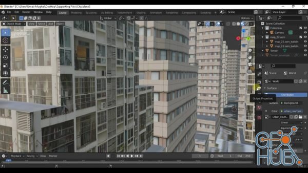
Udemy – Blender city and landscape modeling
Learn modeling 3D topographic landscape and city using autocad and openstreetmap data
What you'll learn
Blender modeling
Import data from OpenStreetMap to blender
City and surface modeling in Blender
Description
Lesson 1 - Introduction
In first introductory lesson, students will know a little about Blender. Some inspirations are shown to students and then they will know a little about the journey onwards. The main focus of this course is on introducing students with;
OSM Add On and M Tree Add On of Blender
Topographic Maps with and without real world map data
Converting AutoCAD to Blender with multiple methods
Rendering a forest and city with and without OSM Add On
Lesson 2 - Hot Keys
Keyboard shortcuts and hot keys are one of the most important part of Blender as there are regular updates observed in Blender so with each upgrade the user interface changes a little, therefore, hot keys are a must to know in order to increase the work flow and efficiency. In lesson 2, complete details of hot keys will be shared, moreover, the PDF file is attached along with video for ease of access.
Lesson 3 – Blender OSM
To get real world data in blender, open street map data is used. In order to get the desired data, Blender OSM add on must be installed and activated. In lesson 3, complete details of downloading and installing methods will be shared, moreover, the add on is attached along with video for ease of access.
Lesson 4 – AutoCAD to Blender Conversion
In lesson 4, in depth details of blender importable formats will be provided. Moreover, two methods will be taught for importing AutoCAD files to Blender. Some Add On needs to be activated in order to successfully import a few extension files.
BLENDER MODELING
Lesson 5 – Height Maps
Height maps are very important when it comes to fetch real world map data in Blender. In lesson 5, students will learn how to access and download height maps from official, free and reliable sources. These height maps will be used to make 3D landscape in lesson 6 and lesson 8.
Lesson 6 – 3D Landscape using height maps
In lesson 6, students will learn how to create a 3D landscape using height maps accessed and downloaded in lesson 5.
It is a complete exercise. If a student follows this exercise completely, he will be able to create a 3D landscape including texturing, lightening and rendering techniques.
Lesson 7 – Topographic Maps (Self-Generated Landscape)
In lesson 7, students will learn how to create topographic maps similar to one that were shown in lesson 4 which were in AutoCAD. In this exercise, students will learn to create a topographic map based on assumed or self-generated landscape.
Lesson 8 – Topographic Maps (Real World Height Map)
In lesson 8, students will learn how to create topographic maps similar to one that were shown in lesson 4 which were in AutoCAD. In this exercise, students will learn to create a topographic map based real world map data using height maps accessed and downloaded in lesson 5.
Lesson 9 – Buildings Textures
In final project (Lesson 12), students will learn how to render a city using real world map data with the help of Blender OSM add on. An important part of city rendering is assigning building material, therefore, in this lesson, students will learn how to access and download copy right free high resolution textures that can be used for personal practice or commercial projects. Three different free as well as paid websites will be shared from where students can get the required building textures.
BLENDER MODELING
Lesson 10 – OSM Data to Blender
In final project (Lesson 12), students will learn how to render a city using real world map data with the help of Blender OSM add on. It is very important for students to understand the working principal and limitations of free Blender OSM add on, therefore, in this lesson students will learn how to select real world map data and import in blender in multiple steps like Terrain, Image Overlay and 3D buildings import.
Lesson 11 – Final Project 1
In final project 1, students will learn how to render a forest landscape right from scratch without using any real world data or Blender OSM add on, however, students will learn how to use MTree add on and HDR environments. Furthermore, students will learn how to access a source having variety of HDR files completely free and CC0 licensed that can be used for personal practice and commercial projects.
Lesson 12 – Final Project 2
In final project 2, students will learn how to render a city landscape right from scratch using the real world map data using Blender OSM add on. In order to save time first all buildings will be assigned a specific material afterwards; students will learn how to add another building material to multiple buildings using duplicate methods. It will be up to students, they can duplicate same method repeatedly by adding as many more building materials as required to make scene more realistic. Concepts like rendering and HDR environment taught in final project 1 will not be repeated to save time.
Download links:

Blender city and landscape modeling.part1.rar
Blender city and landscape modeling.part2.rar
Blender city and landscape modeling.part3.rar
Blender city and landscape modeling.part4.rar
Blender city and landscape modeling.part2.rar
Blender city and landscape modeling.part3.rar
Blender city and landscape modeling.part4.rar


Comments
Add comment
Tags
Archive
| « July 2026 » | ||||||
|---|---|---|---|---|---|---|
| Mon | Tue | Wed | Thu | Fri | Sat | Sun |
| 1 | 2 | 3 | 4 | 5 | ||
| 6 | 7 | 8 | 9 | 10 | 11 | 12 |
| 13 | 14 | 15 | 16 | 17 | 18 | 19 |
| 20 | 21 | 22 | 23 | 24 | 25 | 26 |
| 27 | 28 | 29 | 30 | 31 | ||
Vote

New Daz3D, Poser stuff


New Books, Magazines