Autodesk Civil 3D: 3D Drawing Techniques
 2021-12-18

 2 017
2 017
 0
0
Udemy - Autodesk Civil 3D: 3D Drawing Techniques
Autodesk Civil 3D: Drawing Techniques
What you'll learn
You will learn the basic functions of the interactive and dynamic Civil 3D software, with the narration of the map engineer Cemil Yüksel.
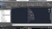
Organization of project data
Ability to work with points
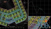
Creating surfaces and making changes
Creating the route plan and road model
Land leveling and volume calculations and construction of infrastructure (pipe) projects
Requirements
Basic computer knowledge
Autodesk AutoCAD
Autodesk Civil 3D
Description
Autodesk Civil 3D; is a land and civil engineering design software with powerful functions. Civil 3D is the biggest difference from the software produced in this regard; It creates intelligent relationships between objects, objects are dynamically updated as soon as there is a change in design, all Civil 3D objects are linked to each other. For example, profiles are updated automatically as soon as a change is made on the route. Its easy-to-use interface provides users with great convenience in the production, management and sharing of projects. Design, analysis, reporting and 3D visualization can all be done with Civil 3D. In the video content, we will talk about Civil 3D and customized field and civil engineering techniques.
Design better civil infrastructure with Civil 3D
Civil 3D civil engineering design software supports BIM (Building Information Modeling) with integrated features to improve drafting, design, and construction documentation.
Project Explorer for Civil 3D
Transform how you navigate, visualize, and interact with Civil 3D design models. Project Explorer is exclusive to Civil 3D in the AEC Collection.
Simplify design review and modification.
Efficiently validate that design objectives are met.
Automate custom report and table generation.
Advance your workflows with GIS integration
Work with ArcGIS data directly in your Civil 3D design model and ensure teams maintain access to up-to-date project information.
Who this course is for
Map engineers
Civil engineers
Download links:

Autodesk_Civil_3D_3D_Drawing_Techniques.part1.rar - 999.0 MB
Autodesk_Civil_3D_3D_Drawing_Techniques.part2.rar - 999.0 MB
Autodesk_Civil_3D_3D_Drawing_Techniques.part3.rar - 999.0 MB
Autodesk_Civil_3D_3D_Drawing_Techniques.part4.rar - 999.0 MB
Autodesk_Civil_3D_3D_Drawing_Techniques.part5.rar - 999.0 MB
Autodesk_Civil_3D_3D_Drawing_Techniques.part6.rar - 999.0 MB
Autodesk_Civil_3D_3D_Drawing_Techniques.part7.rar - 999.0 MB
Autodesk_Civil_3D_3D_Drawing_Techniques.part8.rar - 398.9 MB

Autodesk Civil 3D 3D Drawing Techniques.part1.rar
Autodesk Civil 3D 3D Drawing Techniques.part2.rar
Autodesk Civil 3D 3D Drawing Techniques.part3.rar
Autodesk Civil 3D 3D Drawing Techniques.part4.rar
Autodesk Civil 3D 3D Drawing Techniques.part5.rar
Autodesk Civil 3D 3D Drawing Techniques.part6.rar
Autodesk Civil 3D 3D Drawing Techniques.part7.rar
Autodesk Civil 3D 3D Drawing Techniques.part8.rar


Comments
Add comment
Tags
Archive
| « July 2026 » | ||||||
|---|---|---|---|---|---|---|
| Mon | Tue | Wed | Thu | Fri | Sat | Sun |
| 1 | 2 | 3 | 4 | 5 | ||
| 6 | 7 | 8 | 9 | 10 | 11 | 12 |
| 13 | 14 | 15 | 16 | 17 | 18 | 19 |
| 20 | 21 | 22 | 23 | 24 | 25 | 26 |
| 27 | 28 | 29 | 30 | 31 | ||
Vote

New Daz3D, Poser stuff


New Books, Magazines